

Every year hundreds of cyclists embark on the journey through one of the Mecca destinations for adventure cycling: the M41, more mystically known as the Pamir Highway. One of the highest highways in the world, second only to the Karakorum Highway, it winds through many 4000m+ peaks and the Roof of the World, the highest plateau on Earth.
If you are contemplating cycling the fantastic mountains of Tajikistan and Kyrgyzstan, this guide will give you all the info you need to know before embarking in one of the hardest and most rewarding cycling adventure.
ROUTE PLANNING
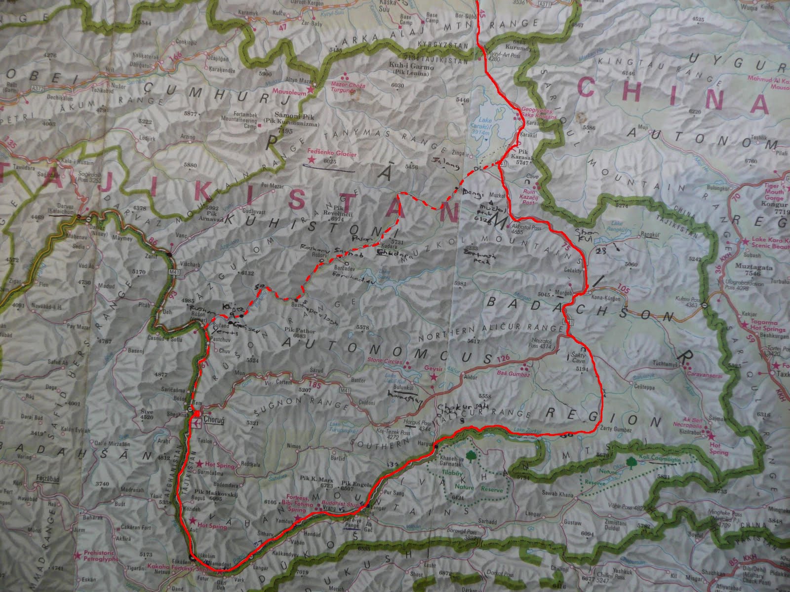
Officially the Pamir Highway stretches from Khorog, at the border between Tajikistan and Afghanistan, and Osh, in Kyrgyzstan. However, most cycle tourers will start in Dushanbe and finish in Osh, covering a total distance of about 1250km.
Map 1 – The Pamir Highway from Dushanbe to Osh, 1620 km
The general consensus from many cyclists before us, agrees that doing the Pamir Highway the opposite direction (from Osh to Dushanbe) is far more challenging due to constant headwinds, steeper climbs, and a more drastic altitude gain, which increases the chances of altitude sickness. Difficult, yes, but not impossible. In fact, you will see many cyclists coming that way, too.
Once you leave Dushanbe you will need to make a series of decisions on how to make your way to Osh. How you decide to follow will be strongly dependent on your shape, resilience, and thirst for a challenge. The time of the year will also influence the feasibility of riding certain roads over others.
From Dushanbe: North or South route?
Upon leaving Dushanbe, the next main stop is the town of Kala-i Khum which can be reached through two different routes. Following the M41 out of Dushanbe for about 20km, you will arrive in the town of Vahdat. Just after crossing the bridge over Kafirnigan river, a roundabout will give you the option to stay on the M41 (281km total Dushanbe to Kala-i Khum) or to take the South route- also known as Kulob road – on the E008 (366km total).
Both roads will rejoin in Kala-i Khum, but they are fundamentally different.
Map 2 – The South route, through Khulob
The North route (M41 – following Map number 1) goes through amazing valleys, the surreal town of Talvidara, and then up to Saghirdasht Pass, at an altitude of 3252m. It is meant to be the hardest part of the whole M41, as the road turns to harsh gravel 110km after Dushanbe and stays so MOST of the way. The whole climb to the pass – and subsequent descent – are quite challenging as big rocks and loose gravel make it difficult to leisurely move forward. The scenery, however, will stun you with dramatic views as you go through canyons and tight valleys. Bear in mind, though, that this route is suitable only during the summer months, being completely open to traffic only from late May to early November. The traffic is generally very quiet and the number of cyclists on the road tends to be greater than motorized vehicles.
The South road, open all year-round on the contrary, is often considered to be easier as it climbs through farmland and open country on good quality tarmac. After descending in the town of Nurek, it ascends again to reach the “Blue Sea” – Nurek Reservoir – through dunes and desert. A 1436m pass will then take you to the town of Shuro Obod, with the last 10km of the climb made of loose gravel. The climb is 30km long, with some 8% sections. The road will then finally descend for 20km down to the Panj River, which is the physical border of Tajikistan and Afghanistan. After a narrow gorge and a final 26km of particularly bad roads, you’ll finally make your way into Kala-i Khum. Apart from the bigger towns, shops are generally few and far between. Small village magazins tend not to sell instant noodles and often run out of bottled water (although streams can be found fairly often). After Shuro Obod there are no shops for about 75km. The traffic is quiet but regular, with drivers being considerate and friendly. There are two tunnels: a 5km one just after the first climb, and 2km one after the second climb. Lighting and ventilation are poor.
[Thank you,
From Rushan: M41 or Bartang Valley?
In Rushan, the road will split once again giving you the chance to either stay on the M41 (Map 1) or divert towards the Bartang Valley. If you stay on the M41, you will follow the Panj river and the Afghan border on slowly improving tarmac until Khorog – a base for many to rest and refuel.
Some of the most adventurous cyclists will wave goodbye to the M41 in Rushan and follow promises of highly unkept roads, river crossing, and absolute wilderness and remoteness in the Bartang Valley.
Map 3 – The dotted line is the unpaved road through the Bartang Valley. Photo credit Cycling High Asia
It starts in Rushan, about 50 km north of Khorog, and rejoins the M41 in Karakul via Kök Jar. It has a long stretch of about 150-200 km of non-human presence (the whole valley counts only 15 houses), sandy and rocky trails, with cyclists reporting the need of pushing their bikes and take a good few days worth of food with them. The Bartang Valley, however, offers the most varied and scenic views in the whole of Pamirs, including the presence of many historic ruins and fortresses. The road is paved only for the first 10km out of Rushan then degrades drastically. Shops, as you would expect in an area so scarcely populated, are very few and sell only instant noodles, potatoes, onions, and eggs. The locals will generally eat what they produce. Few people that we know of, have actually embarked on this route. Make sure you have everything you need to repair your bike, filter water, and feed yourself as it might be difficult to come across some help in case of physical and/or mechanical breakdown. [You can read stories of first-hand experience in the Bartang Valley here and here]
Both roads will meet once again just before Karakul Lake, North-East of Tajikistan.
If you have more info on the Bartang Valley or would like to add/correct something, click here.
From Khorog: M41 or Wakhan Valley?
M41 (Map 1). From Khorog, the first 10km of the M41 out of town are quite steep, but the roads are paved and not too busy, leading you towards a valley dominated by the vivid blue of the Gunt river, and surrounded by snow-capped peaks. You will go through Jelandi and the hot springs to then climb towards Koitezek Pass. The last 3-4 km of the climb are quite steep AND on rough gravel, with some 12% sections. But upon reaching the top you will be on the Roof of World and one of the most famous plateaus worldwide. The next larger villages following the M41 are Alichur and Murghab. The road between the two is usually blessed with tail winds (not a given though!), which make the short Neizatash Pass a piece of cake. The descent is on good quality tarmac and the views are astonishing as you go through red sand valleys and barely any human presence.
Wakhan Valley (Map 4, below, brown lining).

Map 4 – Wakhan Valley in brown color (photo credit: Caravanistan)
The road to the Wakhan Valley starts South of Khorog, following the Panj river and the Tajik/Afghan border. Ishkashim is the first big town you will encounter (110km), in which there’s a famous Afghan market every Saturday. The landscape is dry and dusty; yet, villages are abundant, always surrounded by the verdant green of trees and grasses, contrasting the surroundings. The final part of the Wakhan is the most challenging. After Langar, there is no sign of for 3 days and you’ll need to carry food supply. Like everywhere in the Wakhan, shops are exceedingly basic. As mostly everywhere in rural Tajikistan households bake their own bread, and you can ask the people you met if you could buy a loaf. After Langar, the traffic reduces drastically as the road becomes sandy and almost impossible to cycle. Soon after, the road tops out at 4,300m, before bursting abruptly back onto the tarmac of the Pamir Highway, just before Alichur.
If you have more info on the Wakhan Valley or would like to add/correct something, click here.
WEATHER & TEMPERATURES
The high altitudes through which the Pamir Highway travels make it a challenging destination, requiring warm clothes even during the summer months. While the weather is much more stable and predictable from May to September, strong winds and storms can happen anytime. We cycled the Pamir Highway in September and, whilst we were very lucky and enjoyed sunny weather for most of the time, by the end of the month we found ourselves in a snow/rainy storm that lasted for a whole week. Generally, the roads are very unkept, especially until Khorog, and they can be completely washed away by landslides, with local authorities stopping you from going any further.
Above 3000m of altitude night temperatures easily reach -5C. From October onward, you should definitely expect snow and night temperatures dropping to -10/-15C. It is a challenging experience, both for mind and body, and unless you are begging to taste your “survival” mode we would advise against winter expeditions.
EATING AND DRINKING
Before embarking on our own journey on the Pamir highway we had read somewhere that September is probably the best month for finding fresh fruit and vegetables. While this is true in bigger towns such as Kala-i Khum and Khorog, keep your expectations low for the rest of the route. The range of vegetables is not that varied either: potatoes, onions, peppers, cucumbers, carrots, tomatoes, cabbage, and eggplants seem to constitute the main and only diet. The fruit range limits to apples, pears, grapes and, very rarely, bananas. In the countryside, you’ll find local shops, which tend to sell instant noodles, eggs, loads of biscuits and chocolate bars. Fresh food is VERY rare.
Drinks-wise, all the shops have some sort of fizzy drinks and iced tea. Bottled water is not sold most of the time and having a SteriPen saved us for the whole duration of our journey. Bear in mind that water boils at less than 100C at higher altitudes; it is, therefore, recommended to sterilize the water you will want to cook with.
For those craving alcoholic beverages, beer and vodka are limited in rural areas but can be found in bigger villages. Wine is generally not available, and if you are planning on a bubbly celebration on top of Ak Baital pass we would suggest bringing your own supply from Dushanbe 😉 .
SLEEPING
The beauty of the Pamir Highway is that you can sleep in every possible place imaginable. In bigger towns such as Dushanbe, Kala-i Khum, Khorog, Murghab, and Osh there is an extensive array of hostels and guest houses to pick from. In the last few years, tourism has caught up in the more remote villages, too. You will often find handwritten signs directing you to homestays and guest houses. Generally, prices range between $10 and $15USD, always including breakfast and, most of the time, also dinner. Home Stays will generally offer you a mattress to lie on the floor, which we found fairly comfortable. The house is heated by burning cows’ dry stool in the central heater/stove and they get quite warm and cozy (or claustrophobic, depending on your point of view).
Wild camping is easy and allowed pretty much anywhere; use common sense and strongly avoid proximity to border posts and military bases. On the Maps.Me app, you’ll find some suitable or scenic camping spots marked under “camping” on both North and South routes. Most are good but not all of them are completely reliable (especially on the South road, where one of the marked camping spots is actually a military base – someone’ s “sense of humor”). Watch out for land mines warnings both on the South route and in the last few Kms up to Saghirdasht Pass, on the North route.
Locals are usually very hospitable and you can ask to pitch your tent in somebody’s garden or farmed land. We have never been refused any help by knocking at any door. Just remember that most of the people living in the countryside are very poor and is always very nice to leave some “thank you” dollars or somoni. At your discretion.
For other ideas and alternative solutions, we suggest to have a look at this hilarious blog!
A FEW PLACES WORTH OF MENTION:
Dushanbe: Green House Hostel. We loved it for the friendly and homely environment. The people running the hostel are efficient and very kind, and they give you the chance to store some of your belongings at the hostel if you want to ride a loop in Uzbekistan or Tajikistan. You can exchange money, pay with a credit card, or use USD/Euros. It has a nice courtyard, which is usually filled with cyclists fixing their bikes. A perfect spot to get into the Pamir’s mood, meet a lot of people and, perhaps, find someone else to ride with if you are traveling solo. Double rooms $35; Dormitory $10. Breakfast included. WiFi usually works pretty well, unless it’s packed with people, in which case can be pretty slow.
Sari-Tash: Hotel Muras. A simple and functional hotel of the size of a guesthouse. The food was delicious and the place really been taken care of by two young women from Bishkek. First encounter with Western toilets and decent toilet paper since Khorog! $16 Breakfast and dinner; $11 with Breakfast only. The WiFi works really well. Open only during the Summer season; closed from October.
Osh: TES House Hostel. Clean and well organized. On leaving Dushanbe we sent a few parcels here to lighten our panniers. After a few weeks and upon arriving at Tes, we found our parcels securely stored. Double rooms $37; Dormitory $10; Tent space $7; GREAT breakfast included and the WiFi is really fast, too.
MOUNTAIN PASSES ON THE M41
Here’s a breakdown of every pass on the M41. All the elevations and distances are automatically generated by Map My Ride and there might be some small altitude discrepancies. Nothing you can’t climb, though!
Hi ! Thanks a lot for all those useful information and details.
How long was it from Dushanbe to Osh ? And what was your mean daily distance ? Have a nice ride, regards.
Th.
Hello! It took us roughly a month, but that includes at least 6 rest days along the way. We would do an average of 60km everyday – some days more with good tail winds, and some days less to avoid eccessive altitude gain so not to suffer of altitude sickness. We are on Strava under “Rolling East” if you want to check out the daily rides. And we did the same on Instagram (@rolling.east), if you want to see some pics too. Feel free to ask any other question if you need. Happy rolling!
Hi Rolling East! Thanks a lot for your answer.
Another question : do you know if high passes of M41 are snow free in June or July ? Strava informations on daily ride are perfect !
I would say they are – that’s summertime in that area, and the snow doesn’t normally kick in until oct/Nov.
The high passes should be snow free in June/July and temperatures might even be quite pleasant 🙂
Great ! Thanks !
Hey, did you use a water filter? If so what sort, I have never used one before.
Hi! Yes, a water filter was essential for us on the Pamir and I think it was one of the many precautions we took in order not to get sick. We have a SteriPen and it is fantastic. It kills bacteria with UVA rays and in 30 seconds. A lot of people use chalks filters but to be honest with you it’s a very lengthy process. We definitely reccommend the SteriPen: fairly small, batteries lasted a long time, and quick! I hope this helps, but if you have any other question don’t esitate asking
A great blog, thanks. I am planning on doing the Pamirs later this year (currently in frozen France en route). What are the opportunities like for buying cooking fuel? I have a multifuel stove so can use petrol, gas or paraffin.
Hi! we had a multifuel stove too and during the Pamirs we used petrol, which could easily be found at least once every few days. We tended to stock up in bigger cities like Khorog and Murghab. Even though petrol is regrettably dirtier than gas, we knew it would last us a good while..
That’s great. Thanks for replying. Enjoying your Instagram posts from SE Asia as I was there earlier this year.
Pingback: Planning Stage 6 – The Pamir Highway (Tajikistan) – Zazzles and her Travels